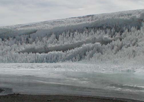
Neve Penetentes covered by this year's snow.
Short Stories
Beware the rotten ice.
Beware the hidden Neve Penetentes! It sounds like a warning from a dungeons and dragons game. But these ice blades are real and dangerous.
We didn't cross any glaciers, however tongues of snow covered ice blocked our way several times. Avoiding the ice meant a long detour or a climb up a short cliff covered with dangerously loose lava blocks. We were tempted to cross the ice.
In the cold morning air the ice crossings went well. However, in the afternoon they gave us problems. Bob set out across one ice field and was over halfway across when the surface layer broke through and dumped him armpit deep into a hole. Paul and I were a hundred yards away and yet even at that distance we could hear Bob breathing hard as he extracted himself from the hole. As he tried to return across the ice he fell through again and again. Each time required a strong effort to get out. When he finally reached solid land again his boots were full of ice chips from his falls.
Later on I decided to cross another ice tongue. The same thing happened to me. Suddenly I was up to my armpits in the ice. I could now see the problem first hand. On top was a layer of this year's snow, about a foot thick. Below was a layer of neve penetentes, ice swords four feet high. The swords were separated by holes. This year's snow made a roof over the holes. When the desert sun had weakened the roof we would plunge through into the ice blades. Luckily in all of our falls the ice blades missed the more delicate parts of our anatomy!
The only one who successfuly managed to find a way to walk across the ice was Tony, I guess ice climbing sharpens your eye for choosing a route through rotten ice.
Navigation
The maps and space photos were essential,however, they were incomplete and occasionally wrong. But such are the adventures you encounter on a first ascent. The GPS receivers were extremely useful and saved us several times.
We planned to follow Quebrada Arenal toward the mountain. This was a good choice. It was a flat floored dry wash that rose gently for several kilometers. It provided us with an easy to follow and very safe route. It ended with a rather steep climb to a plateau at 5200 meters where we planned to put camp 1.
Above this plateau the map showed a glacier which was confirmed as a patch of white on the space photo. It was white all right, but it wasn't a glacier, it was volcanic ash! Luckily there was a tiny patch of snow next to our chosen campsite. Seven days later as we cleaned up camp 1 this snow patch had entirely vanished. We were really lucky.
Camp 2, at 5500 meters elevation was closer to a permanent ice field. Beyond camp 2 however was a maze of lava and ice. Multi-mile-long lava flows over 100 feet high were separated by valleys full of neve penetente rich ice. The lava flows were high enough to block our view of the route and even of the summit, however they were too small to show up on the topographic map which had 150 foot (50 m) contour intervals. Luck was with us as we found an excellent way across the lava fields.
Finally at 9 AM on the summit day we got our first clear view of the summit. I had begun to think of the mountain as "Hidden Peak." We were all pleased to see an obvious route to the top.
I set my GPS to record our hiking path. On our return I used the "trackback" feature to retrace our path exactly. This was a big help because the lava all looked the same and it would have been easy to get lost.
In fact when Bob's boots filled with ice and we had to split the group to rush him back to camp Paul and Tony did lose the route back. Tony had been smart however and stored camp 2 as a waypoint on his GPS. Even though he got off the route we had followed to the mountain, he followed his GPS back to our tent.
It ain't over.
We were happy to have climbed the mountain and looked forward to returning to civilization for a bath and real food. We packed the truck climbed in and then...nothing happened, the car would not start. A quick survey showed that we were in trouble. Maxi would come to rescue us in 3 days yet we only had water for 1 day! I figured out a way to stay alive, with 2 liters of water I could hike back up the mountain and return in a few hours with a backpack full of 50 pounds of ice.
Paul Morgan had a better idea. He is a race car driver engineer and really knows cars. Soon he had the engine exposed and the spark plugs out. They were wet with fuel. With a little thought he realized that Pancho was using the choke and that at 15,000 feet that made the mixture far to rich. So Paul cleaned and dried the spark plugs over the camp stove, put off the choke, gave the engine just a little gas, and with the last bit of battery power got it started. Whew! It's nice to have a car expert along!
We took no chances on the way out, we chose our route carefully to avoid getting stuck in the sand a long way from water. I kept surveying the surrounding mountains for patches of snow and ice we could reach in case we did get stuck.
Car Navigation
On the way in to the mountain we followed the gash eroded by the Rio Juncal to the Juncalito Hot spring turnoff and then climbed up the side of the canyon through the gash of a dry wash to the rim of a huge plateau. Maxi asked us to carefully mark the upper end of the wash on our GPS receivers so that Pancho could be sure to find it on our return. This gash was the only way down from the plateau to the river. The plateau was covered by with gently rolling gullies all looking the same. I put in a few waypoints along the way to help us on the return.
When we got near our mountain Maxi turned to me and said, OK you navigate now. That gave me a shock. I pulled out the map and GPS and in a few minutes was directing him to drive up Quebrada Arenal. A mistake in these few minutes would have put us in the wrong quebrada or even on the wrong mountain. The GPS really helped.
On the way out I used the waypoints I had set earlier to help Pancho find the route. The plateau was criss-crossed by old tire tracks. The waypoints helped us exactly retrace our path. We celebrated when we arrived precisely at the top of the gully leading down to the Rio Juncal. Pancho assured us that the water in the river below us was "agua dulce" sweet drinkable water.
Adapting to Altitude
On our first trip to the Andes in 1993 Bob and high went too high too fast and suffered from severe mountain sickness. That taught us the importance of taking enough time to adapt to altitude. This trip we decided to adapt in style. We flew in to Santiago and immediately got driven to Valle Nevado ski lodge at 10,000 feet. There is nothing like adapting to altitude at a 3 star hotel.
This was the first year that Valle Nevado was to be open in the summer. We had arrived after the end of the ski season and before the start of mountain bike season and were the only guests in the entire hotel.
Each day we went out to climb a peak. On the day of our arrival we climbed to the top of a high ski lift at 11,000 feet. The next day we scaled Tres Puntas. On our last day Paul and I climbed to the 13,000 foot summit of LaParva. Each day we climbed 1000 feet higher this was an easy acclimatization schedule.
We flew from Santiago to 7,000 foot high El Salvador and lost a bit of our adaptation. But the next day we drove to base camp at 14,800 feet. This was a real test of our adaptation, and we all did fine.
We took two days exploring the route to camp 1 then on the third day cut loose from base camp and moved to camp 1 at 17,000 feet Bob and I scouted ahead to find the route to camp 2. A few of us had mild headaches at night. The next day we moved up to camp 2 at 18,000 feet. Summit day we climbed to 20,100 feet. We noticed that we had to breathe more often at 20,000 feet but were well enough adapted to enjoy our visit to the summit.
My biggest advice to first-time high altitude climbers is take the time to adapt to altitude. Enjoy the mountain scenery and you'll keep free of the horrible headaches accompanying Acute Mountain Sickness.
High altitude can be deadly. Your lungs can fill with fluid, in high altitude pulmonary edema or HAPE, and even your brain in high altitude cerebral edema, HACE. Your vision can become blurred due to high altitude retinal hemorrhage, HARH. Worst of all, your tent mates may expel you into the cold if you contract HAFE, high altitude flatular expulsion. Acute mountain sickness, AMS, is a warning signal that you have gone too high too fast, its migraine like headaches and nausea are sure to get your attention. If you get AMS stop going up and give your body time to adapt to altitude. Even better, go down it will bring immediate relief.